تواجه مناطق واسعة من الولايات المتحدة، خصوصا في ولايات الغرب الأوسط، عاصفة جوية عنيفة تهدد عشرات الملايين من السكان، وسط تحذيرات من فيضانات مفاجئة وأعاصير قوية قد تكون مميتة.
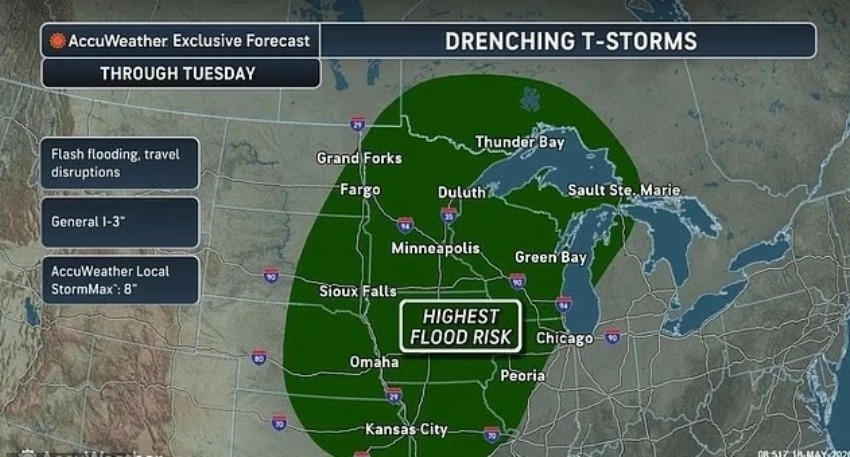
وأصدرت هيئة الأرصاد الجوية الوطنية الأمريكية تحذيرات من عواصف رعدية شديدة وسيول محتملة في ولايات عدة، من بينها ميشيغان وإنديانا وإلينوي وآيوا وكانساس وميزوري ونبراسكا وأوهايو.
أعاصير تضرب ولايات أمريكية
وأكد خبراء الأرصاد أن أعاصير عدة بدأت بالفعل بملامسة الأرض في ولاية نبراسكا، فيما دعت السلطات السكان إلى الاحتماء الفوري مع اتساع رقعة العواصف الخطرة.
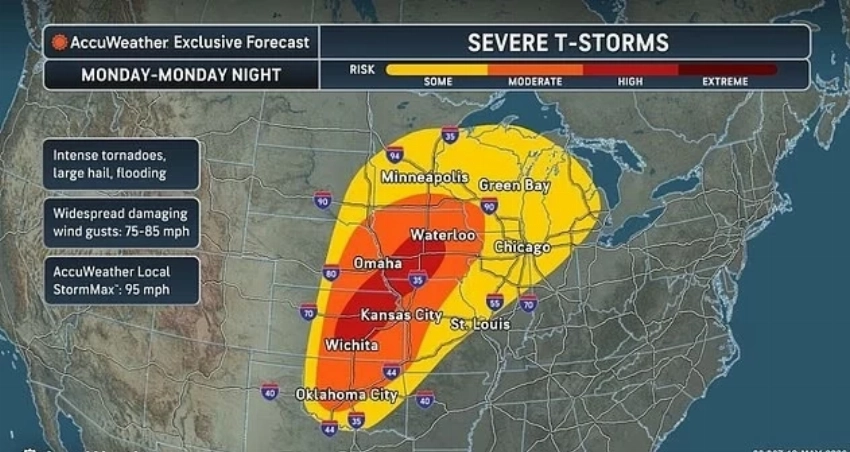
ومن المتوقع أن تمتد الأحوال الجوية القاسية إلى ولايات ويسكونسن ومينيسوتا وداكوتا وأوكلاهوما، مع توقعات برياح مدمرة تتجاوز سرعتها 75 ميلاً في الساعة، إضافة إلى تساقط حبات بَرَد ضخمة واحتمال تشكل أعاصير واسعة النطاق.
المناطق الأكثر عرضة للعواصف
وحذرت مؤسسة «أكيو ويذر» من أن مدناً كبرى مثل شيكاغو وكانساس سيتي وأوماها ومينيابوليس وأوكلاهوما سيتي ستكون ضمن المناطق الأكثر عرضة للعواصف العنيفة خلال ساعات الليل.
كما يُتوقع أن تتسبب الرياح الشبيهة بقوة الأعاصير في أضرار واسعة للمنازل والمنشآت التجارية، مع احتمالات كبيرة لانقطاع التيار الكهربائي في عدد من الولايات.
وصنفت السلطات أجزاءً من جنوب آيوا ونبراسكا وشمال غرب ميزوري ووسط كانساس باعتبارها المناطق الأكثر عرضة لتشكل «أعاصير شديدة الخطورة».
وقال كبير خبراء الأرصاد في «أكيو ويذر»، بيتون سيمرز، إن التوقعات تشير إلى إمكانية تسجيل ما بين 24 و50 إعصاراً خلال الفترة الممتدة من مساء الإثنين وحتى صباح الثلاثاء.
تحذيرات في عشرات المقاطعات
وفي الوقت نفسه، أصدرت هيئة الأرصاد تحذيرات من الأعاصير في عشرات المقاطعات بولايتَي كانساس ونبراسكا، مع استمرار حالة التأهب حتى ساعات الليل.
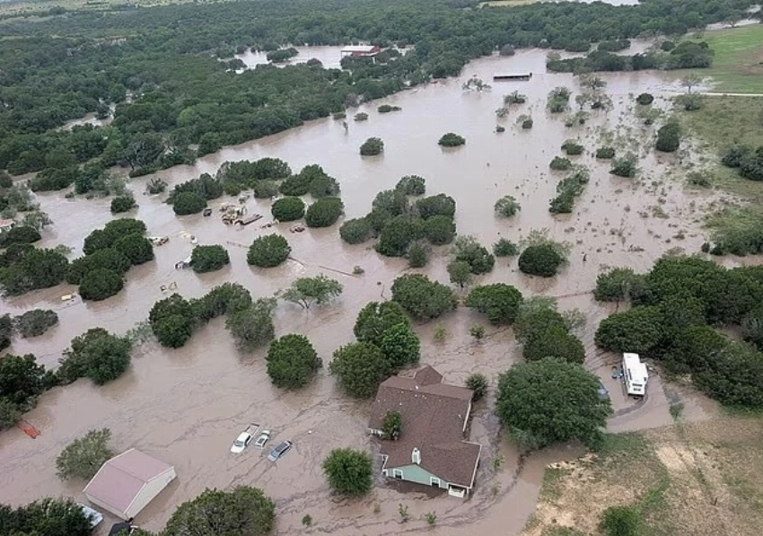
كما حذرت السلطات من أمطار غزيرة قد تتجاوز أربع بوصات في بعض المناطق بميزوري ونبراسكا، ما قد يؤدي إلى فيضانات خطرة نتيجة عجز التربة عن امتصاص كميات المياه الكبيرة.
وأوضح خبراء الطقس أن هذه العواصف قد تتحول إلى ما يُعرف بـ«السوبر سيل»، وهي أخطر أنواع العواصف الرعدية وأكثرها قدرة على إنتاج أعاصير مدمرة قادرة على اقتلاع الأشجار وتدمير أسقف المنازل.
وتتشكل الأعاصير نتيجة أعمدة هوائية شديدة الدوران تمتد من السحب إلى سطح الأرض، وتتفاوت قوتها من أعاصير ضعيفة تسبب أضراراً محدودة إلى أعاصير هائلة يمكنها تدمير المنازل وقلب السيارات.
ويُقاس تصنيف الأعاصير وفق سرعة الرياح، بدءاً من الفئة EF0 وحتى الفئة EF5 التي تتجاوز فيها سرعة الرياح 200 ميل في الساعة وتستطيع اقتلاع المباني من أساساتها.
فيضانات مفاجئة
وفي المقابل، يرى خبراء الأرصاد أن خطر الفيضانات المفاجئة قد يكون الأكثر تأثيراً هذا الأسبوع، مع توقعات بغمر مناطق واسعة في مينيسوتا وويسكونسن وميشيغان وإلينوي وآيوا وميزوري ونبراسكا وكانساس.
وأشار المختصون إلى أن الفيضانات الخاطفة قد تبدأ خلال أقل من ثلاث ساعات فقط من هطول الأمطار الغزيرة، بخلاف فيضانات الأنهار التي تتطور تدريجياً على مدى أطول.
ويعزو خبراء الطقس هذه الظواهر الجوية العنيفة إلى تصادم الهواء الدافئ والرطب القادم من خليج المكسيك مع كتل هوائية أبرد وأكثر جفافاً تتحرك شمالاً، إلى جانب تأثير ما يُعرف بـ«قص الرياح»، الذي يساعد على تشكل العواصف الدوارة القوية.
كما يؤدي الخط الفاصل بين الهواء الجاف والحار القادم من الجنوب الغربي والهواء الرطب والدافئ إلى رفع الهواء بشكل انفجاري، ما يساهم في نشوء العواصف العنيفة داخل المنطقة المعروفة أمريكياً باسم «ممر الأعاصير».
وأضاف خبير الأرصاد بيتون سيمرز، أن بعض المناطق قد تشهد تساقط حبات بَرَد يتراوح حجمها بين كرة الغولف وكرة البيسبول، الأمر الذي يشكل خطراً كبيراً على السائقين والممتلكات والأشخاص الموجودين في الأماكن المفتوحة.
Large areas of the United States, particularly in the Midwest states, are facing a severe storm threatening tens of millions of residents, amid warnings of flash floods and powerful tornadoes that could be deadly.
The National Weather Service has issued warnings of severe thunderstorms and potential flash floods in several states, including Michigan, Indiana, Illinois, Iowa, Kansas, Missouri, Nebraska, and Ohio.
Tornadoes Strike American States
Forecasters confirmed that several tornadoes have already touched down in Nebraska, while authorities urged residents to seek immediate shelter as the area of dangerous storms expands.
Severe weather conditions are expected to extend to Wisconsin, Minnesota, the Dakotas, and Oklahoma, with forecasts of destructive winds exceeding 75 miles per hour, in addition to the possibility of large hail and widespread tornado formation.
Areas Most Vulnerable to Storms
AccuWeather warned that major cities such as Chicago, Kansas City, Omaha, Minneapolis, and Oklahoma City will be among the areas most susceptible to severe storms during the night hours.
Winds resembling tornado strength are also expected to cause widespread damage to homes and commercial buildings, with a high likelihood of power outages in several states.
Authorities have classified parts of southern Iowa, Nebraska, northwestern Missouri, and central Kansas as the areas most at risk for "extremely dangerous tornadoes."
AccuWeather's chief meteorologist, Peyton Simmers, stated that forecasts indicate the possibility of recording between 24 and 50 tornadoes from Monday evening to Tuesday morning.
Warnings in Dozens of Counties
Meanwhile, the weather service has issued tornado warnings in dozens of counties in Kansas and Nebraska, with a state of alert continuing into the night hours.
Authorities also warned of heavy rainfall that could exceed four inches in some areas of Missouri and Nebraska, which could lead to dangerous flooding due to the soil's inability to absorb large amounts of water.
Meteorologists explained that these storms could evolve into what is known as a "supercell," which is the most dangerous type of thunderstorm and has the greatest capacity to produce destructive tornadoes capable of uprooting trees and destroying roofs.
Tornadoes form from highly rotating air columns that extend from clouds to the ground, varying in strength from weak tornadoes that cause limited damage to massive tornadoes that can destroy homes and flip vehicles.
The classification of tornadoes is measured by wind speed, ranging from EF0 to EF5, where wind speeds exceed 200 miles per hour and can uproot buildings from their foundations.
Flash Floods
Conversely, meteorologists believe that the risk of flash floods may be the most impactful this week, with predictions of widespread inundation in Minnesota, Wisconsin, Michigan, Illinois, Iowa, Missouri, Nebraska, and Kansas.
Experts noted that flash floods can begin within less than three hours of heavy rainfall, unlike river floods that develop gradually over a longer period.
Weather experts attribute these violent weather phenomena to the collision of warm, moist air coming from the Gulf of Mexico with colder, drier air masses moving northward, along with the effect known as "wind shear," which helps to form strong rotating storms.
The boundary between the dry, hot air coming from the southwest and the moist, warm air causes explosive lifting of the air, contributing to the formation of violent storms in the area known in America as "Tornado Alley."
Meteorologist Peyton Simmers added that some areas may experience hailstones ranging in size from golf balls to baseballs, posing a significant danger to drivers, property, and individuals in open spaces.
ملحوظة: مضمون هذا الخبر تم كتابته بواسطة عكاظ ولا يعبر عن وجهة نظر مصر اليوم وانما تم نقله بمحتواه كما هو من عكاظ ونحن غير مسئولين عن محتوى الخبر والعهدة علي المصدر السابق ذكرة.